Property Record
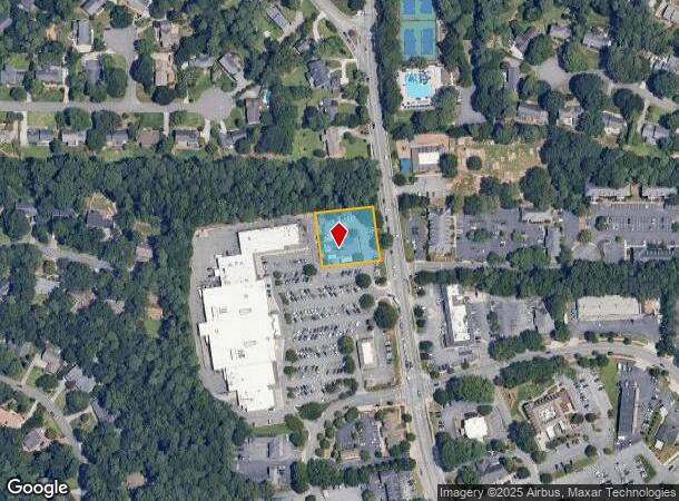
5592 Chamblee Dunwoody Rd, Atlanta, GA 30338

NEARBY LISTINGS FOR SALE OR LEASE
Property Detail
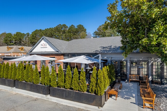
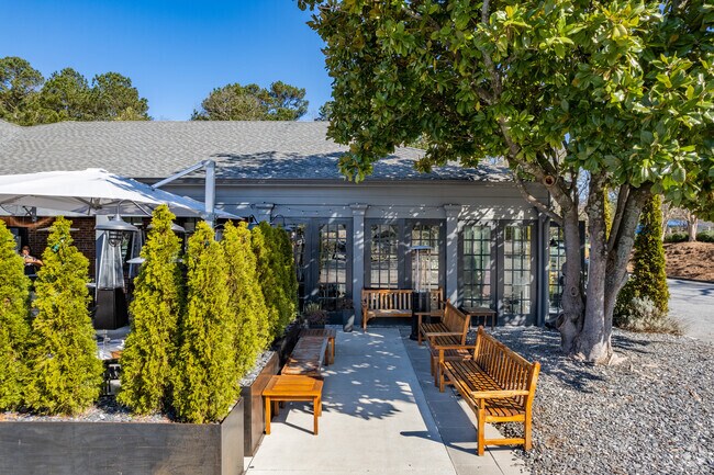
5592 Chamblee Dunwoody Rd
18-366-01-009
DeKalb
Restaurantbuilding
Georgia
X
9
13089C0005K
0.62 AC
2025
Sandy Spring/N Ctrl
2025
Atlanta
021213
Atlanta-Sandy Springs-Roswell, GA
3,254 SF
DEMOGRAPHICS near 5592 Chamblee Dunwoody Rd
1 Mile
3 Mile
5 Mile
2024 Total Population
10,539
94,556
237,295
2029 Population
10,489
95,020
240,214
Pop Growth 2024-2029
(0.47%)
+ 0.49%
+ 1.23%
Average Age
39
39
39
2024 Total Households
3,814
43,367
102,056
HH Growth 2024-2029
(0.37%)
+ 0.63%
+ 1.36%
Median Household Inc
$148,585
$96,520
$95,174
Avg Household Size
2.70
2.10
2.30
2024 Avg HH Vehicles
2.00
2.00
2.00
Median Home Value
$692,989
$523,049
$537,944
Median Year Built
1981
1987
1986
Nearby Places
Map Layers
Map Styles
 Street
 Aerial
- Restaurants
- Banks
- Shops
- Fitness
- Groceries
PUBLIC TRANSPORTATION
AIRPORT
Hartsfield - Jackson Atlanta International
DRIVE
WALK
Distance
Hartsfield - Jackson Atlanta International
39 min
25.7 mi
Nearby Properties
Address
Land Use
TOTAL SIZE
Lot Size
Zoning
Address
Land Use
TOTAL SIZE
Lot Size
Zoning
1,123,714 SF
47.33 AC
C1
Address
Land Use
TOTAL SIZE
Lot Size
Zoning
854,744 SF
2.04 AC
OI
Address
Land Use
TOTAL SIZE
Lot Size
Zoning
374,311 SF
0.19 AC
X
Address
Land Use
TOTAL SIZE
Lot Size
Zoning
216,464 SF
X
Address
Land Use
TOTAL SIZE
Lot Size
Zoning
104,625 SF
0.99 AC
X
Address
Land Use
TOTAL SIZE
Lot Size
Zoning
409,493 SF
10.01 AC
OI
Address
Land Use
TOTAL SIZE
Lot Size
Zoning
376,010 SF
3.76 AC
OI
Address
Land Use
TOTAL SIZE
Lot Size
Zoning
543,090 SF
5.51 AC
R2
Address
Land Use
TOTAL SIZE
Lot Size
Zoning
701,195 SF
20.76 AC
X
Address
Land Use
TOTAL SIZE
Lot Size
Zoning
439,052 SF
4.57 AC
OI
Address
Land Use
TOTAL SIZE
Lot Size
Zoning
519,706 SF
6.70 AC
X
Address
Land Use
TOTAL SIZE
Lot Size
Zoning
485,132 SF
37.90 AC
OI
Address
Land Use
TOTAL SIZE
Lot Size
Zoning
296,627 SF
9.21 AC
X
Address
Land Use
TOTAL SIZE
Lot Size
Zoning
542,845 SF
10.58 AC
X
Address
Land Use
TOTAL SIZE
Lot Size
Zoning
664,199 SF
2.85 AC
Address
Land Use
TOTAL SIZE
Lot Size
Zoning
937,800 SF
2.65 AC
Address
Land Use
TOTAL SIZE
Lot Size
Zoning
295,885 SF
3.50 AC
X
Address
Land Use
TOTAL SIZE
Lot Size
Zoning
258,909 SF
19.01 AC
X
Address
Land Use
TOTAL SIZE
Lot Size
Zoning
140,183 SF
4.20 AC
OI
Address
Land Use
TOTAL SIZE
Lot Size
Zoning
12,342,500 SF
125.51 AC
AC
Address
Land Use
TOTAL SIZE
Lot Size
Zoning
699,202 SF
13.90 AC
OIC
Address
Land Use
TOTAL SIZE
Lot Size
Zoning
1,088,359 SF
7.07 AC
OIC
Address
Land Use
TOTAL SIZE
Lot Size
Zoning
588,846 SF
3.80 AC
Address
Land Use
TOTAL SIZE
Lot Size
Zoning
4,555,620 SF
12.41 AC
OI
Address
Land Use
TOTAL SIZE
Lot Size
Zoning
480,790 SF
5.93 AC
Address
Land Use
TOTAL SIZE
Lot Size
Zoning
204,376 SF
14.23 AC
X
Address
Land Use
TOTAL SIZE
Lot Size
Zoning
106,770 SF
3.13 AC
X
Address
Land Use
TOTAL SIZE
Lot Size
Zoning
366,276 SF
11.54 AC
RM-HD
Address
Land Use
TOTAL SIZE
Lot Size
Zoning
347,179 SF
18.24 AC
X
Address
Land Use
TOTAL SIZE
Lot Size
Zoning
478,332 SF
4.07 AC
The World's #1 Commercial Real Estate Marketplace
Connect with us
© 2025 CoStar Group
The information above has been obtained from sources believed reliable. While we do not doubt its accuracy we have not verified it and make no guarantee, warranty or representation about it. It is your responsibility to independently confirm its accuracy and completeness. Any projections, opinions, assumptions, or estimates used are for example only and do not represent the current or future performance of the property. The value of this transaction to you depends on tax and other factors which should be evaluated by your tax, financial, and legal advisors. You and your advisors should conduct a careful, independent investigation of the property to determine to your satisfaction the suitability of the property for your needs.